This year we have an exceptionally large amount of snow in the entire Northern Hemisphere. The Arctic Meteorology Summit in Levi discusses weather phenomena in the Arctic region.
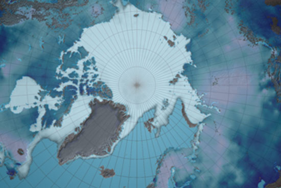
The new "Arctic Now" product developed by the Finnish Meteorological Institute FMI shows with one picture the extent of the area in the Northern Hemisphere currently covered by ice and snow. This kind of information, which shows the accurate state of the Arctic, becomes increasingly important due to climate change. The weather phenomena in the Arctic region are discussed during the Arctic Meteorological Week in Levi.
"This year we have had an exceptionally large amount of snow in the entire Northern Hemisphere. The amounts vary from one year to another, and in recent years there have been great differences between winters", says Kari Luojus, Senior Research Scientist at the Finnish Meteorological Institute.
This information has been gleaned from the "Arctic Now" service of the Finnish Meteorological Institute, which is unique even on a global scale. The greatest difference compared with other similar services is that usually they only tell about the extent of the ice or the snow situation.
"Here at the Finnish Meteorological Institute we have managed to combine data to form a single image. This way we can get a better situational picture of the cryosphere - that is, the cold areas of the Northern Hemisphere", Research Professor Jouni Pulliainen observes.
In addition to the coverage, the picture includes the water value of the snow, which determines the water contained in the snow. This is important information for drafting hydrological forecasts on the flood situation and in monitoring the state of climate and environment in general.
Total amount of snow declines
and snow starts to melt earlier
Information on the amount of snow is sent to the Global Cryosphere Watch service of the World Meteorological Organisation (WMO) where the information is combined with trends and statistics of past years. Lengthy series of observation times show that the total amount of snow in the Northern Hemisphere has declined in the spring period and that the melting of the snow has started earlier in the same period. Study over a longer period (1980-2017) shows that the total amount of snow in all winter periods has decreased on average.
The ice cover on the Arctic Ocean has grown thinner, and the amount and expanse of perennial ice has decreased. Before year 2000, the smallest expanse of sea ice varied between 6.2 and 7.9 million square kilometres. In the past 10 years, the expanse of ice has varied from 5.4 to 3.6 million square kilometres. Extreme weather phenomena - winters in which snowfall is sometimes quite heavy, and others with little snow, will increase in the future.
The Arctic area is warming at twice the speed as the rest of the world, and the impact of climate change can already be seen in the Arctic regions. These changes affect the entire globe.
"What happens in the Arctic regions does not stay in the Arctic regions. The exceptional strengthening of a high-pressure area in Siberia, which brought freezing temperatures to Finland in late February and early March, may be partly the result of atmospheric warming over the Arctic Ocean. When it is exceptionally cold somewhere in the world, it is often exceptionally warm somewhere else. This is what happened in the end of February-early March when temperatures in the North Pole were around zero degrees Celsius and it was exceptionally cold in Europe", explains Ari Laaksonen, Scientific Director at the Finnish Meteorological Institute.
The weather fluctuates from one year to another and individual cold snaps in the Arctic area are not, as such, proof of the progression of climate change. "However, they are a reminder of how climate uncertainty has increased and that we'll have to get use to variations in the weather as the climate change proceeds", Ari Laaksonen observes.
The Arctic Meteorology Summit on 20 March gathers together directors-general of the meteorological institutes of the Arctic countries and various stakeholders in the field from all over the world. Cooperation is important because research and security in the Arctic region require comprehensive and long-term weather, ice, sea, and atmospheric observations and modelling.
"Meteorology is a new theme in the Arctic Council, even though the Arctic countries are already engaging in plenty of cooperation on the subject. The Levi meeting will include discussions on how meteorological know-how will be seen in the future work of the Arctic Council", says Arctic Ambassador Aleksi Härkönen.
Finland’s Minister of Transport and Communications Anne Berner participates in the Arctic Meteorology Summit.
"The challenge of meteorological research is to explain the complicated climate feedback mechanisms in the Arctic region. It calls for extensive cooperation between space, atmospheric, marine and cryospheric researchers, for example. A good example of this is an initiative by the World Meteorological Organisation (WMO) on a climate centre of the Arctic region, where the meteorological institutes in the region would share information to generate joint climate data.”
Minister Berner reminds that the development of meteorological data is not enough in itself but transmission of information and services calls for well-functioning connections and communications networks.
"The Finnish Meteorological Institute has created a research and testing area for intelligent transport and 5G networks in Sodankylä. None of these pilot projects would be possible without good communications networks. We must remember that intelligent transport systems and services are totally dependent on road weather services based on location data", Anne Berner says.
Photos: Snow in Levi (c) Anne Raja-Hanhela/Arctic Centre, Snow and ice map (c) Finnish Meteorological Institute